Home Multi-Country Search About Admin Login
Neogene
Paleogene
Cretaceous


Compiled by: Jacques LeBlanc (2021), Stratigraphic Lexicon: The Onshore Cenozoic Sedimentary Formations of The Republic of Panama. Biosis: Biological Systems, vol. 2/1, 1-173. https://doi.org/10.37819/biosis.002.01.0095(or via https://sites.google.com/site/leblancjacques).

Search by
Select Region(s) to search
Hold Ctrl (Windows/Linux) or Command (Mac) to select multiple
Clarita Formation
Click to display on map of the Ancient World at:
Clarita Fm base reconstruction

Clarita Fm


Period: 
Neogene

Age Interval: 
Lower Miocene to lower part of the Middle Miocene (Aquitanian/Burdigalian/Langhian) - Coates et al. (2004) & Barat et al. (2014)


Province: 
Eastern Panama

Type Locality and Naming

  • Sapper (1937). Clarita Limestone is an undefined name which appears on correlation chart for calcareous strata of Middle Oligocene age in the Darien area. Underlies Arusa Fm.
  • The formation was named by Shelton (1952) for the Clarita River and redefined by Coates et al. (2004). Río Clarita is a small stream about 30km ESE of El Real de Santa Maria. It flows into Río Capetí, which is a southwestward flowing tributary of Río Tuira.
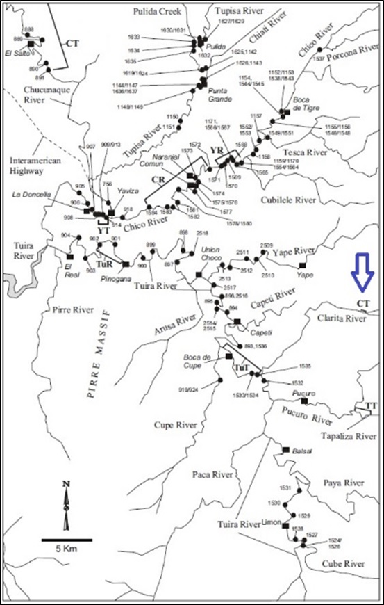
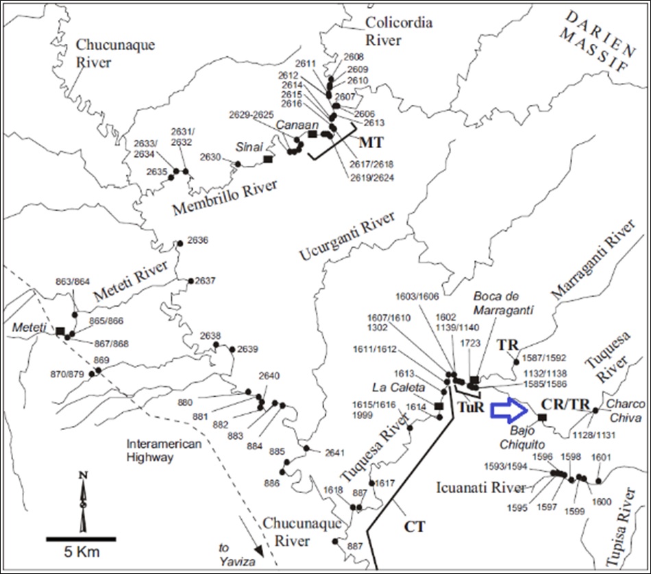
  • The Clarita Fm crops out in the area of the Massifs of Majé and Sanson Hills, and the Basins of Chucunaque–Tuira and Sambu. The stratotype ("CT" on Figure 1) is located on the Clarita River. A reference section studied and named in Coates et al. (2004) is exposed at Charco Chiva ("CR" on Figure 2), about 9 km east southeast of Boca de Marraganti, on the Tuquesa River.

[Figure 1. Locality of the Clarita Fm’s stratotype (CT, marked with a blue arrow). Coates et al. (2004)]

[Figure 2. Locality of the Clarita Fm’s Ref. Section (CR, marked with a blue arrow). Coates et al. (2004)]

Synonym: Clarita Limestone; Clarita Limestone Fm


Lithology and Thickness

On the northeastern flank of the Chucunaque-Tuira Basin, the Clarita Fm is generally indurated, gray-white weathering, pale blue, thick-bedded, crystalline limestone, but may range from chalky to bioclastic with occasional intercalated sandy and shaly units. In the Tuquesa River and Marraganti River sections, it has tuffaceous units interbedded in the upper 50 m. In the lower part, foraminiferal, calcareous, and tuffaceous mudstone are more abundant. On the western flank of the Basin the unit becomes a fine bioclastic limestone, often with a micritic matrix, and with minor components of glauconite, feldspar, and lithic fragments. The limestone clasts may consist of up to 60% foraminifers. The formation is well bedded in units from 10 cm to 2 m and often forms prominent ridges in the field.

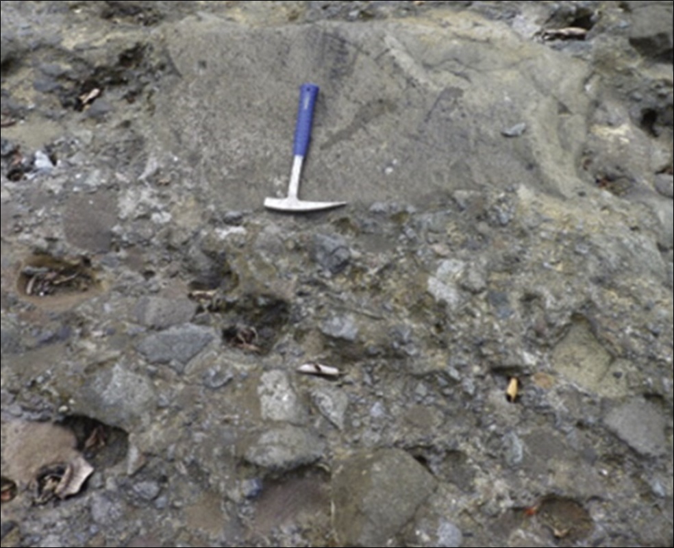
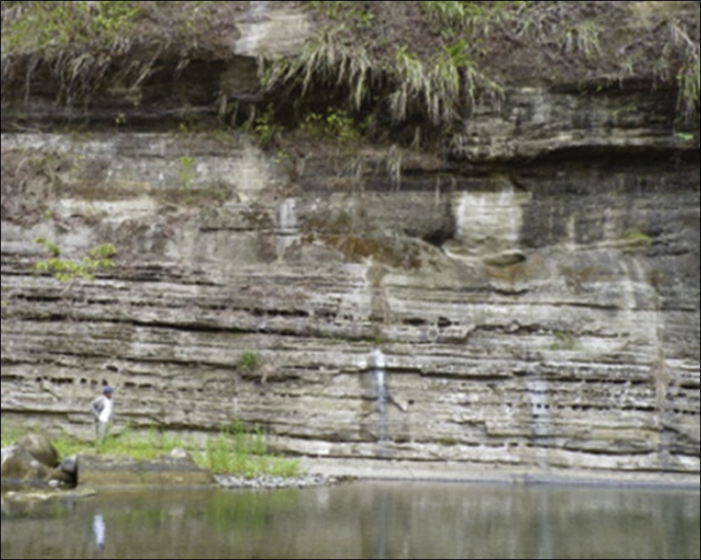
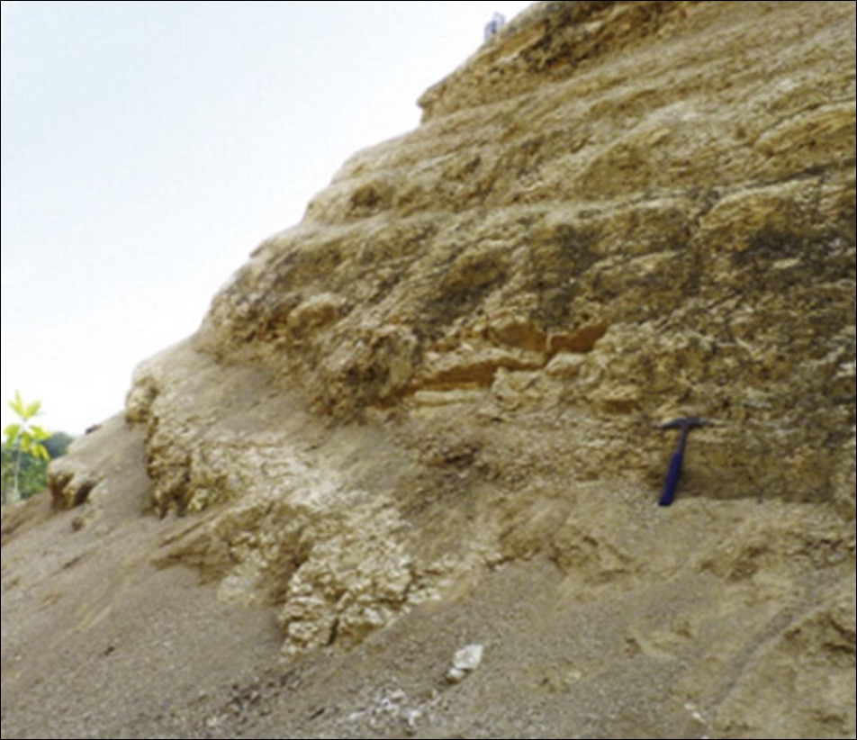
Barat et al. (2014) summarize the Clarita Fm has being made up of clastic sediments with a high content of carbonate fossiliferous clasts. The base of the Clarita Fm is composed of conglomerates and reworked adakitic-like volcanic clasts, as noted in the Majé Massif. The remaining higher stratigraphic sequence alternates between breccia, conglomerate (Figure 3), sandstone, thick layers of calcarenite (Figure 4) and fossiliferous sandstone dated as Early Miocene. The very top of this formation consists of siliceous and calcareous fine tuff and mudstone, located in the Sanson Hills Massif (Figure 5).

Thickness: Its thickness has a minimum of 200 m and a maximum of 2000 m at the center of the Chucunaque–Tuira Basin, according to Coates et al. (2004).

[Figure 3. Outcrops of breccias to conglomerates from the Majé Massif, Clarita Fm (8.94667°, −78.53119°, WGS84). Barat (2013) and Barat et al. (2014).]

[Figure 4. Calcarenites of Burdigalian from the Majé Massif, Clarita Fm (8.94656°, −78.52829°, WGS84). Barat (2013) and Barat et al. (2014).]

[Figure 5. Calcareous shales of Early–Middle Miocene, from the Sanson Hills, top of the Clarita Fm (8.61528°, −78.12849°, WGS84). Barat (2013) and Barat et al. (2014).]


Lithology Pattern: 
Limestone


Relationships and Distribution

Lower contact

In the Chucunaque Basin, the Clarita Fm conformably overlies the Porcona Fm. In western Darien, it rests with angular unconformity on the Darien Fm. In the Majé Massif, this formation unconformably overlies the Darien Fm, and in the southern flank of the Sapo Massif in the Sambu Basin, the Clarita Fm unconformably overlies the San Blas Complex Fm.

Upper contact

Its upper contact with the Tapaliza Fm is not exposed in the Tuquesa River. In the Membrillo River it is not exposed in one of the fault slices, but is represented in the other by an abrupt lithological change. In the Sambu Basin, it sits nonconformably or with a faulted contact on the Darien Fm. Contact with the overlying Tuira Fm in this Basin is not observed but is probably strongly disconformable given a gap of more than 6 m.y. between the units and their generally parallel strike. Barat et al. (2014)

Regional extent

Eastern Panama


GeoJSON

{"type":"Feature","geometry":{"type":"MultiPolygon","coordinates":[[[[-79.61,9.61],[-79.48,9.64],[-79.23,9.6],[-78.99,9.56],[-78.49,9.45],[-78.08,9.29],[-77.84,9.09],[-77.4,8.7],[-77.35,8.59],[-77.3,8.42],[-77.18,8.02],[-77.26,7.82],[-77.39,7.66],[-77.56,7.46],[-77.73,7.31],[-77.83,7.24],[-77.89,7.24],[-78.01,7.33],[-78.25,7.61],[-78.38,7.9],[-78.43,8.14],[-78.4,8.31],[-78.51,8.49],[-78.64,8.67],[-78.88,8.86],[-79.18,8.99],[-79.35,9.03],[-79.37,9.04],[-79.42,9.09],[-79.52,9.13],[-79.52,9.17],[-79.54,9.21],[-79.54,9.3],[-79.54,9.35],[-79.62,9.34],[-79.7,9.33],[-79.8,9.41],[-79.75,9.49],[-79.61,9.61]]]]}}

Fossils

Not mentioned


Age 

The Membrillo River, Tuquesa River, and Sambu-Venado River sections provide biostratigraphic data indicating that the Clarita Fm in these areas ranges through the lower part of the middle Miocene.

Age Span: 

    Beginning stage: 
Langhian

    Fraction up in beginning stage: 
0

    Beginning date (Ma): 
15.99

    Ending stage: 
Langhian

    Fraction up in the ending stage: 
0.5

    Ending date (Ma):  
14.91

Depositional setting

The Clarita Fm was deposited at lower to middle bathyal depths. Water depth was greatest toward the center of the Chucunaque-Tuira Basin (Membrillo River section). Depths there and in the Sambu Basin were lower bathyal, 1500-2000 m. Clarita Fm sediments were probably deposited at a middle bathyal depth (500-1500 m) in the Tuquesa River section.


Depositional pattern:  


Additional Information

  • Sapper (1937).
  • Shelton (1952)
  • Wilson et al. (1957) mentions Clarita Limestone of Lower Oligocene age.
  • Woodring (1960). Río Clarita is a small stream about 30 kilometers east southeast of El Real de Santa Maria, in Darien area.
  • Coates et al. (2004).
  • Barat et al. (2014).


Compiler:  

Jacques LeBlanc (2021), Stratigraphic Lexicon: The Onshore Cenozoic Sedimentary Formations of The Republic of Panama. Biosis: Biological Systems, 2(1), 173 pp. https://doi.org/10.37819/biosis.002.01.0095 (or via https://sites.google.com/site/leblancjacques)